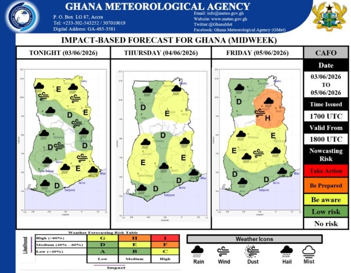
The agency’s Central Analysis and Forecasting Office issued an impact based midweek report covering these dates. Overall risk levels remain low across the country during this period.
Residents should still stay alert for localized weather disturbances during the morning and evening hours. Coastal areas will remain mostly cloudy with scattered thunderstorms and rain expected.
Early morning mist might reduce visibility for motorists and commuters along the coastal belt. Areas just north of the coast will likely experience similar patterns. You can expect early morning fog or mist patches in these regions. Mostly cloudy skies and isolated to scattered thunderstorms will follow the morning mist.
The middle and transition zones also anticipate mostly cloudy conditions. Scattered thunderstorms and rainfall will characterize these zones through the period.By Friday, some middle and transition areas may experience more widespread thunderstorm activity. This could potentially affect your outdoor plans and daily transport operations.
The northern sector will see a mix of sunny intervals and scattered rain. Early morning mist and fog patches are likely during the dawn hours in some northern locations. GMet continuously monitors these ecological zones to provide accurate updates.
Please keep an eye on local forecasts if you plan to travel across these regions before June 6. Staying informed helps you navigate the potential for reduced visibility on the roads. Always prepare for sudden changes in your daily schedule due to the expected thunderstorms.
The weather remains dynamic, so checking official updates from the agency is a smart move. Your safety matters, especially when commuting during early morning fog. Enjoy the balance of sunny intervals and necessary rainfall while staying safe.
Also Read: Dozens Killed as Heavy Rains Trigger Floods in Angola

Source: Emma Ankrah